Learn about new research to understand how accessible, accurate and timely weather, water, ice and climate data support safe navigation in the Canadian Arctic.
|
Getting your Trinity Audio player ready...
|
The Role of Weather, Water, Ice and Climate Data for Arctic Navigation
Dr. Jean Holloway is a research associate in the Environment, Society and Policy Group (ESPG) at the University of Ottawa, conducting research on climate change in the Arctic. She completed her PhD in terrestrial science at the University of Ottawa in 2020 focusing on permafrost thaw and forest fires. When the opportunity came up to work with Dr. Jackie Dawson, Jean pivoted to undertake new research on maritime and climate issues in the Arctic.
Tell us about a project you are currently working on
As the focus for my postdoctoral work, I have been leading a project called “The Role of Weather, Water, Ice and Climate (WWIC) Data for Arctic Navigation” in collaboration with others in the ESPG at the University of Ottawa, with support from Clear Seas to scope and launch the study. The objective of this project is to determine what climate information seafarers in the Canadian Arctic need to navigate safely.
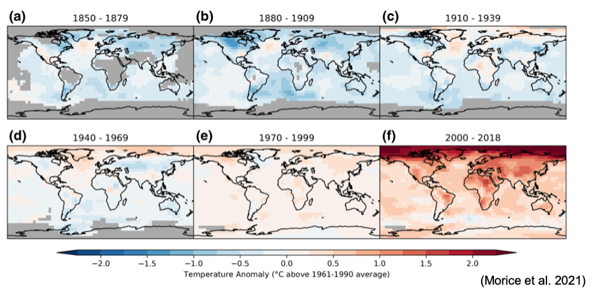
For context, the Intergovernmental Panel on Climate Change (IPCC) Sixth Assessment Report issued in 2021 indicated that the Arctic has warmed at twice the global rate on average, with winter temperatures increasing at three times the global rate. The rate of warming has become more rapid in recent years, as shown in the figure below, and is expected to continue to the end of 21st century. This is also leading to an increase in precipitation across northern Canada, and more extreme events.
Rate of warming in the Arctic (1850-2018)
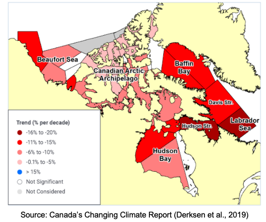
Of particular interest for maritime shipping are the changes in sea ice: how and when and where it forms. The Canadian Arctic experienced a dramatic drop in sea ice coverage starting in 2000 and this is expected to continue under all the climate warming scenarios, making the Arctic even more accessible to marine traffic. Under scenarios with high greenhouse gas (GHG) emissions, the Arctic could be ice-free in the summer by 2050 or 2060. The changes are also regional and variable. Multi-year ice is becoming thinner, there’s more first-year ice forming, and the ice overall is more mobile and harder to predict, increasing the level of hazard for Arctic seafarers. Ice arches are no longer forming in key areas, which allows ice to flow into new areas. For example, there have been icebergs off the coast of Newfoundland and Labrador earlier in the season. More open water areas will favour the development of higher waves and potentially hazardous extreme wave events.
Trends in total Arctic summer ice (1968-2016)
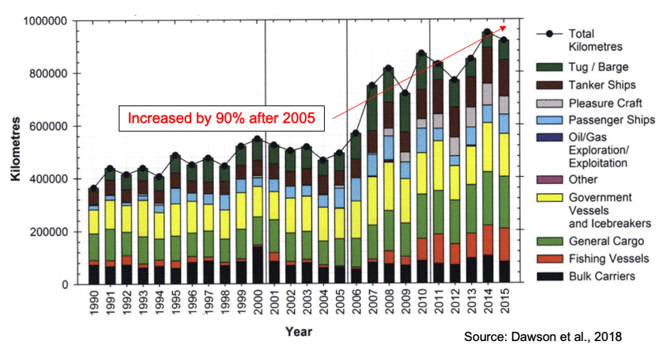
Changing sea ice conditions along with other shifting socio-economic factors has led to an increase in shipping activity throughout the Canadian Arctic. Ship traffic was fairly stable from 1995 to 2005, but since 2005, we have seen a dramatic increase – 90% more traffic. Of particular concern is the increase in the number of yachts and fishing vessels built without ice strengthening. Ill-prepared vessels combined with increasingly mobile and hazardous sea ice can lead to disastrous consequences, such as the Argentine sailors who required rescuing in 2018. These changes in vessel traffic are putting the Arctic environment and the people who depend on it at risk.
Changes in Arctic vessel traffic (1990-2015)
What is the key message of this study?
To reduce navigational risk in the Arctic, mariners need to be able to rely on weather, water, ice and climate information that is usable, accessible, and accurate.
What are the objectives of this study?
With this study, I have been focusing on how technology can be applied to limit risk and prevent accidents. Technology includes innovations like hull strengthening to resist ice, navigational aids, and more detailed marine charts, but it also includes information about the environment. Vessel operators rely on data about weather, water, ice and climate (WWIC) to make safe navigational decisions, just as we all use this type of information to support our decisions about whether to bring an umbrella when we go outside. This study has assessed where and how mariners are getting this information, how they use it, and what data gaps exist for the Arctic region.
What is the problem you are trying to solve?
If mariners in the Arctic cannot access the information they need (e.g., a poor internet connection), or they can access the information but it’s not in a user-friendly format or is out of date (e.g., a week-old ice chart), they are not going to be able to make good decisions for safe navigation.
The problem is that services to provide WWIC information in the Arctic are limited, with limited infrastructure and few monitoring locations. As well, there’s a gap between what information is being created and what the vessel operators need. The user experience is often overlooked.
This study was aiming to understand what WWIC information people are actually using, whether that information was meeting their needs, if there are different information needs for different vessel types, and how WWIC services could be improved.
This study focused on pleasure craft operators in particular, as the fastest growing sector of marine traffic in the Arctic, with a high potential for incidents as these vessels are often not ice-strengthened.
How did you approach this study and what were the results?
I developed a mixed-methods survey using Qualtrics, an online software, to ask questions of mariners. I appreciated the help of the Clear Seas team in developing the survey questions and identifying potential survey participants.
The survey received 56 responses from all vessel types, except fishing vessels. Of those, 40% were pleasure craft operators. Of all respondents, 57% were ship captains or skippers and their experience with Arctic navigation ranged from 1 to 30 years. However, there was a significant difference in terms of experience between pleasure craft operators and those operating other vessel types – 61% of pleasure craft operators had less than 1 year of experience navigating in the Arctic.
Surprisingly, most of the mariners said that their WWIC information needs were frequently being met with good information, but 63% indicated that information could be improved, especially with more frequent or real-time observations.
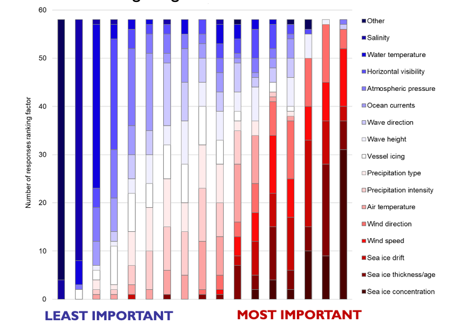
When asked to rank individual WWIC factors based on relevance for navigational decisions, responses indicated that sea ice concentration, thickness, and drift, followed by wind speed and direction were the most important. Least important were salinity, vessel icing and water depth. Of the factors ranked as important, mariners wanted to see information provided within 1-5 days or ideally in real time. For spatial data, responses varied, with interest in both detailed and coarse-resolution information. Advances in satellite technology and improved ice charting were noted as particularly desirable.
Navigational factors ranked by importance to seafarers
For all WWIC factors, the Northwest Passage was identified as an area where information was regularly inaccurate. Respondents felt information about sea ice was particularly inaccurate, especially in the Foxe Basin, Gulf of Boothia, southern Hudson Bay and James Bay, as well as in the Arctic Ocean north of Ellesmere Island.
Where were services most inaccurate?
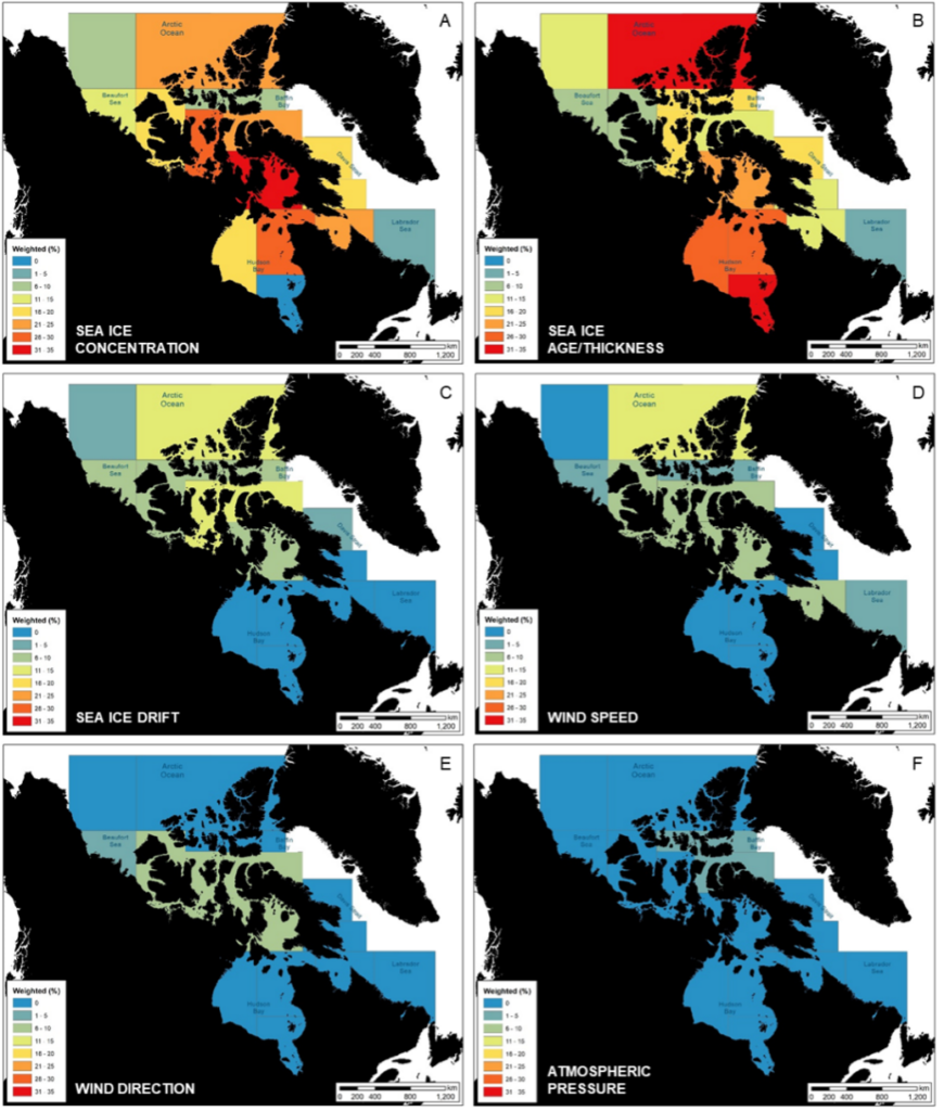
Most users were happy with the usability and accessibility of existing services, but found challenges with internet connectivity, especially in the Northwest Passage. Some of the pleasure craft operators had no internet access for the duration of the voyage. For improvements in the information itself, operators wanted to see more frequent updates, such as wind speed and direction information issued twice daily instead of daily, and more and better satellite coverage.
Overall, mariners were really happy about the level of services in Canada but could benefit from more information and more ways to access that information, like small text files without graphics or information that can be transmitted over radio or satellite phone. Better WWIC information would make Arctic voyages safer and easier.
What challenges did you experience?
I was relatively new to qualitative studies and although I received great support from the research team about how to conduct a survey, in terms of framing the questions and being careful not to lead the responses, in retrospect, I would have asked some questions slightly differently. I found some of the questions were interpreted differently than intended.
The lack of responses from fishing vessels was disappointing, as they are an increasing segment of marine traffic in the Arctic. Connecting with fish harvesting organizations could have yielded more responses from this segment.
The information provided through these surveys was interesting but one-on-one interviews with operators would provide more nuanced information about why they are accessing certain products.
When will this work be published and by whom?
We are in the final stages of drafting a manuscript and plan to publish it in summer 2024.
How has your research been applied / how do you hope it will be applied?
I prepared a research summary document and shared it with WWIC service providers to highlight the results of where services can be improved or provided differently to better meet the needs of different groups of mariners. My goal was to connect users with producers to start the conversation about how to make better products. For example, information that is more accessible while in the Arctic, issued in real-time or near real-time.
How was this research funded?
I received funding and support from a number of sources, including the Social Sciences and Humanities Research Council of Canada (SSHRC/CRSH), ArcticNet, the Marine Environmental Observation, Prediction and Response Network (MEOPAR), Canada Research Chairs, and Clear Seas.
What do you wish everyone knew about your research?
Two things:
1) I wish all users knew where the best and most accurate WWIC information can be found; and
2) I wish all service providers knew exactly what the user needs were so they could tailor their services to meet them.
I think my survey is a starting point to address this, but there is more work to be done. I did send final data reports to all the mariners who participated in the study and reports to service providers to hopefully achieve these two goals.
What do you wish everyone knew about commercial marine shipping?
As someone who is relatively new to the industry, I was astounded by just how much commercial marine shipping is going on, especially in the Arctic, where you might think there’s nothing. Yet there are sailboats going through the Northwest Passage, even during the COVID-19 pandemic when most recreational and non-essential shipping shut down. For example, someone from New Zealand came through the Northwest Passage in his sailboat and no one knew about it until someone living in Cambridge Bay called the Coast Guard to report him.
It is so important to regulate and stay on top of the potential impacts, rather than having to play catch up by responding to a potentially catastrophic incident and then coming up with policy or regulations.
What inspires you to do this work?
I’m really inspired by applied research – research that feels useful to society and policymakers.
I am passionate about working with users of data – vessel operators in this case – to understand their needs, but I’ve also worked with Inuit and northerners to understand more about their experience with WWIC information and shipping. I feel inspired when I hear that someone has an issue or concern, and I am able to use my skills to help in some way.
Do you have any tips for others interested in doing similar work?
If you want to navigate a change to a more applied type of research, I recommend finding a mentor to help. Another important consideration is directly engaging with data users. Go out and talk to users, the community you are trying to help. Talking to people directly is essential. They know what research they need, where the information gaps are. Take your topic from what is needed already. The old, “top down” approach, where you glean gaps from scientific articles, do research, and then present it to communities, is shifting. In early career researchers, we are seeing a more holistic and collaborative, bottom-up approach to build a research project with a community. However, this is hard to do as a single project. Finding a mentor, supervisor, or research team to collaborate with is essential.
What is next for you?
Publishing the results in an open-source journal so that they are accessible to everyone.
I am interested in comparing these results to what is happening in the European Arctic to understand differences and similarities in WWIC sources and needs. Two researchers are working in the European Arctic on a similar project (SALIENSEAS), and we have been in touch with the Norwegian Ice Service who are very interested in the user-experience and want to collaborate.
Our sample size was very small, so we could not fully understand the nuances between all vessel types. I would really like to learn more about the WWIC needs of fishing vessels, in particular. And it would be very interesting to do more detailed interviews with operators about why they are accessing certain products.
Where can we learn more?
For more information about the projects I am currently working on, visit:
For more information about WWIC in the Arctic:
Inuit community WWIC information needs: https://straightupnorth.ca/community-wwic-uses-and-needs/
WWIC in the European Arctic: www.salienseas.com
Article: Navigating Weather, Water, Ice and Climate Information for Safe Polar Mobilities from the Polar Prediction Project Societal and Economic Research and Applications (PPP-SERA) working group, who started the conversation on WWIC needs in the Arctic.
Article: Arctic shipping trends during hazardous weather and sea-ice conditions and the Polar Code’s effectiveness from the Development Centre for Weather Forecasting, Norwegian Meteorological Institute, the University of Oslo, and The Arctic University of Norway
